
The Narrow Strait of Hormuz and its Long Winding History
How 39 kilometres of water became the hinge of the world

This piece was first published on A Man Who Blogs on Substack last night. Substack subscribers received it 24 hours ago. Subscribe at amanwhoblogs.substack.com/subscribe to get every Sunday Deep Dive the moment it drops.
I have a habit at dinner parties. When the conversation turns to global trade, which it does in Singapore more reliably than you might expect, and someone starts explaining with the particular confidence of someone who read an article that morning that “the Suez Canal is really the critical hinge of global commerce,” I wait. I let them finish the thought. I even nod, slightly. And then I say: Hormuz.
The pause. The slight frown. The quiet recalibration.
“The Strait of Hormuz?”
“Yes.”
“Isn’t that... the Iran thing?”
“It’s the everything thing.”
I’ve been doing this for about fifteen years. It is, I’ll admit, mildly insufferable. But there’s a specific pleasure in loving a place before the world needs it, in carrying a fact the way you carry a good book recommendation, knowing your moment will come. Political geography has always done this to me. Not the broad outlines of empires, borders, and capitals but the narrow places. The passes, the river confluences, the tight channels of ocean where history compresses into a single point. I find them more interesting than almost anything else.
The Strait of Hormuz has been my favourite for years. It sits between Iran and Oman, 39 kilometres wide at its navigable throat, barely the distance from London’s Heathrow Airport to the Bank of England, and through it flows approximately 20% of the world’s entire oil supply every single day. It even sounds, as I’ve always told my Parsi friends, like a particularly distinguished uncle.
I’m writing this on a Saturday morning. You’ll read it on a Sunday, or perhaps later, given how fast this situation is moving. By the time these words reach you, the Strait may look very different. Because right now it is closing. Not with a wall or a fleet. With mines. Invisible ones. And the world that has spent fifteen years barely registering the name is suddenly saying nothing else.
This is a piece I never thought I’d write. I never thought the world would catch up, but it feels so apropos.
🏺 The Kingdom That Ran the World From a Waterless Island
The word “Hormuz” is, depending on your scholarly disposition, three things simultaneously.
It is divine: most historians trace it to Hormoz, the Middle Persian corruption of Ahura Mazda, the supreme deity of Zoroastrianism, lord of wisdom, light, and cosmic order. The ancient Persians didn’t just build a trade route here. They consecrated it. You don’t simply transit a place named after God; you negotiate with it.
It is botanical: Hur-mogh, in local dialect, means “place of dates,” a reference to the dense date palm forests that once lined the Hormozgan coast. The name as fertility and scent, the smell of a port before you can see it.
It is Greek: Alexander the Great’s surveyors passed through after his Indian campaign, and hormos in their vocabulary meant bay or anchorage. The name as infrastructure, as shelter, as a sailor’s promise of safe harbour after the Indian Ocean’s open water.
These three etymologies don’t contradict each other. They accumulate. They tell you what kind of place this has always been, the kind that means several things at once to several civilisations simultaneously, which is precisely why everyone has always wanted to control it.
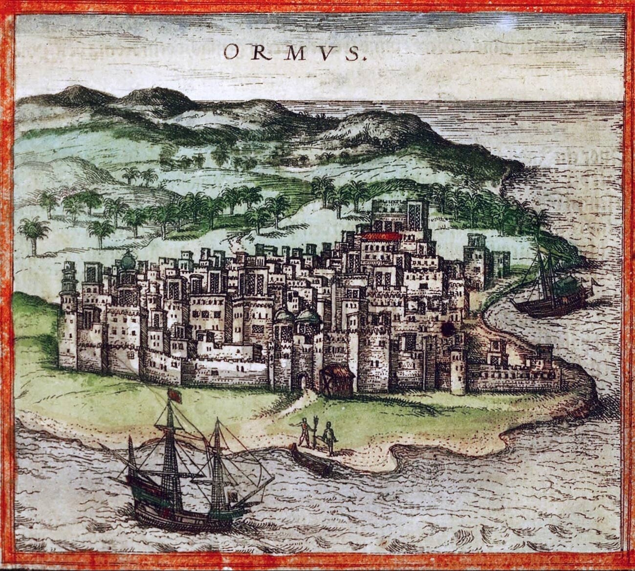
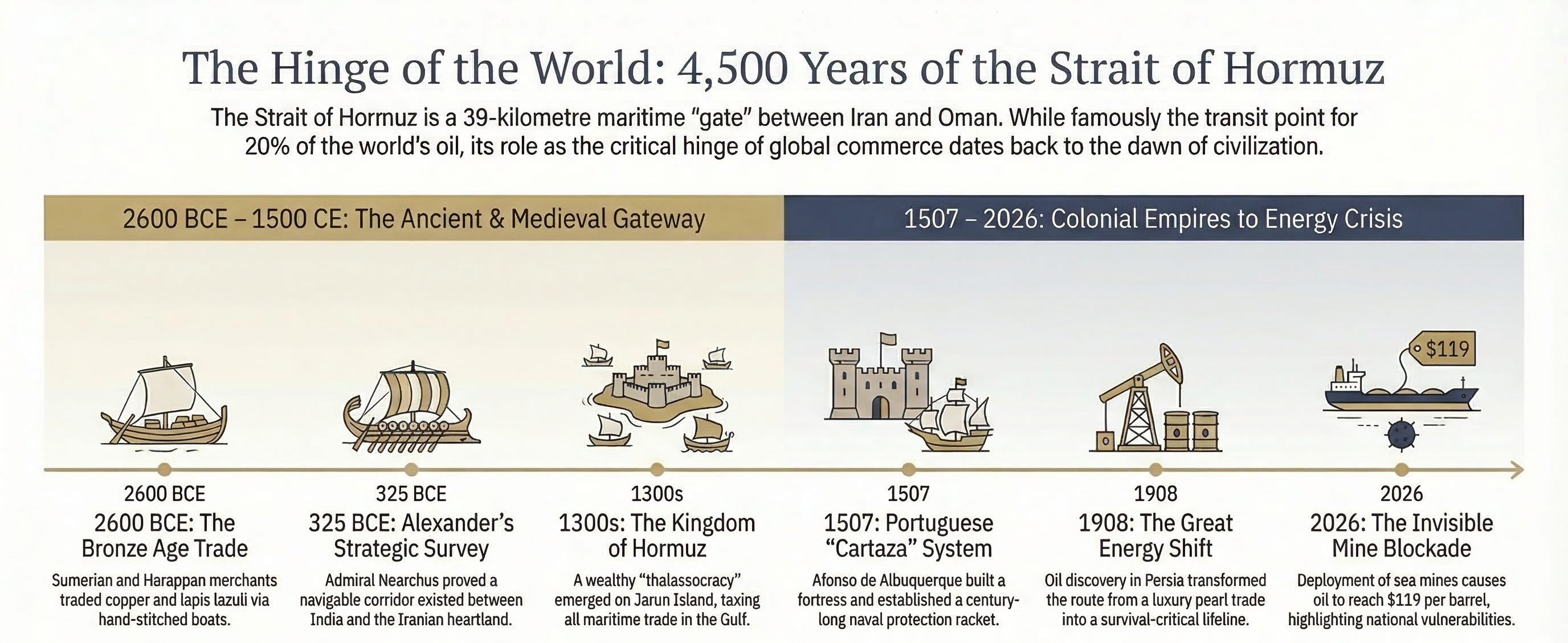
What grew here, between the 11th and 17th centuries, was the Kingdom of Hormuz (Ormus, as European maps labelled it). It was a thalassocracy: a maritime empire whose power derived not from armies or fertile land but from the ability to tax everything that floated past. Founded on the mainland by an Arab chief who migrated from Oman, the kingdom faced an existential threat in 1301 AD when Mongol raiders made the coast untenable. The ruler Baha ud-Din Ayaz relocated the entire population five miles offshore to the island of Jarun. No fresh water. Summer heat so extreme that records describe inhabitants spending daylight hours submerged in the sea to survive the winds. And within a century, it had become the most celebrated trading port on earth.
Contemporary travellers described Hormuz as a cosmopolitan Babel, disorienting, breathtakingly wealthy. Chinese admiral Zheng He sailed his treasure fleets here. A medieval chronicler called it the “ring stone of the world.” Remove it, and the ring falls apart.
Then Marco Polo arrived in 1290, and was horrified. Not by the heat, though the heat was considerable. By the ships. The vessels of Hormuz had no iron nails. They were sewn together with coconut-fibre twine. He was certain many would sink in the Indian Ocean’s open-water storms. He later admitted he had “only told half of what I saw.” He also described, in passing, a whale skull displayed in the city centre, the size of a small building, positioned as a monument to the ocean’s abundance and the city’s taste for spectacle. A whale skull in the town square. This is a place that understands theatre.
⚓ This Was Already the Centre of the World in 2600 BCE
Before oil. Before the Portuguese. Before Marco Polo or his sewn boats. This passage was already where the world’s commerce compressed.
The evidence is archaeological and specific: Indus-style seals found in the Tigris-Euphrates delta, Mesopotamian artefacts unearthed in western India. These fragments point to a functioning maritime exchange as early as 2600 BCE, when Sumerian merchants and Harappan traders were using this water as their primary waypoint. Copper from Magan (modern Oman) crossed this channel to fuel Bronze Age metalworking in Mesopotamia. Teak from the Indus Valley crossed it for the temples of Sumer. Lapis lazuli from Afghanistan crossed it on its way to Egypt.
What we call globalisation, these sailors were doing in hand-stitched coconut-fibre boats, navigating by stars and monsoon across one of the world’s most demanding stretches of open water.
The Achaemenid Persian Empire was the first imperial power to recognise the Strait of Hormuz as a strategic chokepoint to be owned rather than merely used. Alexander the Great arrived next, sending his admiral Nearchus on the first recorded survey voyage from the Indus back to Susa in 325 BCE, proving a navigable corridor between India and the Iranian heartland existed. The passage then moved through Sassanid Persian hands into the Abbasid Caliphate’s unified Islamic trade network, stitching together the Persian Gulf, Southeast Asia, and China centuries before European cartographers had drawn any of it accurately.
Each empire had the same insight. Control the gate, collect the toll. The mechanism changed. The logic never did.
🏴☠️ The Portuguese Protection Racket That Ran for 115 Years
Afonso de Albuquerque arrived in 1507 with cannon and a strategic clarity that impresses even now. He looked at the strait’s geography and understood immediately: whoever holds this holds everything between India and the Mediterranean. He built a fortress on Hormuz island, its sun-bleached walls still visible from the Iranian coast on a clear morning, and implemented the cartaza system: a protection document granting safe passage to allied vessels, leaving uncertified ships vulnerable to seizure or destruction. Portugal ran this arrangement for 115 years.
The expulsion came in 1622 through one of the more pragmatic diplomatic transactions in history. Shah Abbas I of the Safavid Empire lacked a modern navy. The English East India Company lacked a land route into the Gulf. They traded: commercial rights for firepower. A joint siege expelled the Portuguese and opened decades of British influence, the treaties that eventually created the “Trucial States,” which became the United Arab Emirates in 1971.
Which leads me to the piece of geography that almost nobody covers, and which I consider one of the most delightful political puzzles in the world.
The southern coast of the Strait of Hormuz belongs to Oman, specifically to the Musandam Peninsula, a dramatic fjord-carved headland of dark limestone jutting into the strait at its narrowest point. The complication is that Musandam is entirely disconnected from the rest of Oman. A band of UAE territory separates them. Musandam is an exclave.
But here is where the map becomes genuinely strange. Inside the UAE, there is a small pocket of Omani territory called Madha, about 75 square kilometres, surrounded on all sides by the Emirates. An enclave inside a foreign country. And within Madha, there is a small patch of UAE territory called Nawa, a few square kilometres of the Emirates surrounded entirely by Omani Madha, which is itself surrounded by UAE. An enclave within an enclave within an exclave.
I have shown this map to people at dinner tables. They always make the same face, the face people make when they’re sure you’re joking. It is not a joke. It is the residue of colonial-era border negotiations so tortured that they produced a cartographic absurdity that geography departments still use as a teaching example. More practically, it means that Oman, with 4.5 million people and one of the quietest presences in the Gulf, controls the headland directly above the world’s most critical oil shipping lane. You don’t need an army if you own the view.
🛢️ One Oil Strike in 1908 Changed Everything
The economic history of the Strait of Hormuz is divided by a single year: 1908.
Before that, the wealth of these waters was aristocratic and curated. Hormuz was the global centre of the pearl trade, the Persian Gulf’s shallow beds producing the finest natural pearls sought by courts from Versailles to the Mughal Durbar in Delhi. Arabian horses crossed this water. Spices, textiles, and precious stones. Power derived from taxing luxury goods in transit, not from extracting resources from the earth.
In 1908, oil was struck at Masjid-i-Suleiman in southwestern Persia. The shift was slow at first and then overwhelming. As of 2025, approximately 20% of the world’s entire global oil supply transits this maritime chokepoint every single day. Roughly 20.9 million barrels. The equivalent of approximately 1,300 supertankers per month, each one longer than the Eiffel Tower is tall, all threading through a navigable lane roughly 3 kilometres wide in each direction.
The energy dependency is not evenly distributed, and this asymmetry is the most under-discussed aspect of the current oil supply disruption. China takes approximately 48% of the Gulf crude that exits through the strait. India, 90% dependent on imported energy, takes 15%. Japan, 87% import-dependent, takes 10%. South Korea, 81% import-dependent, takes 8%. The United States, buffered by domestic production, is far less exposed. These are not trade statistics. They are national vulnerability scores.
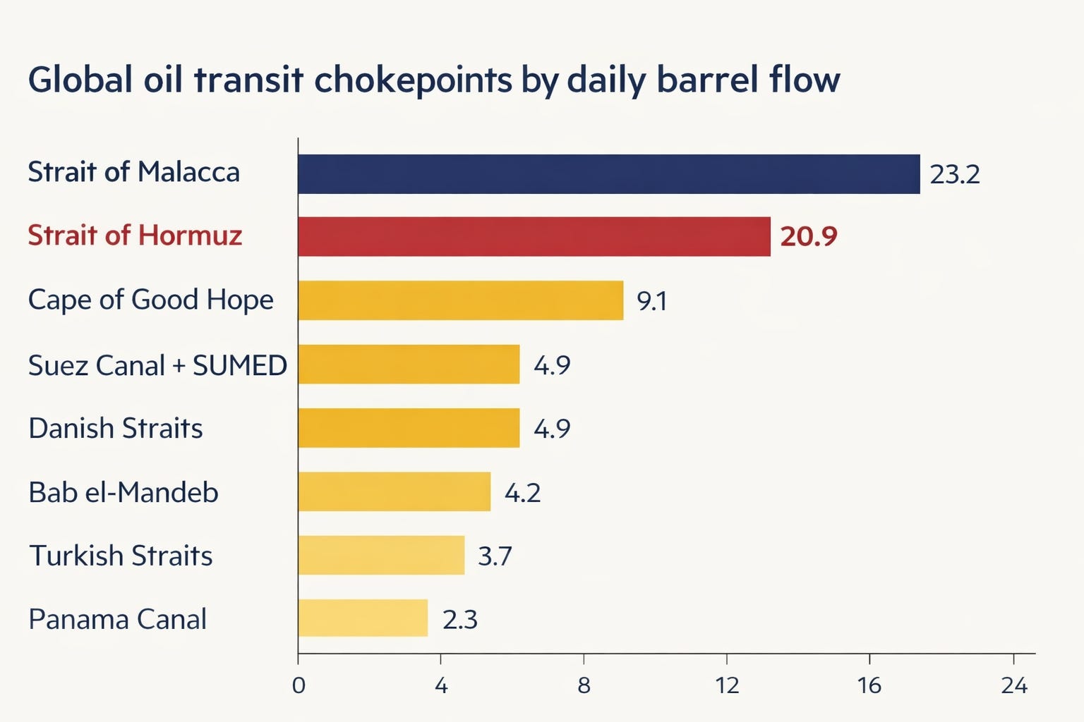
The Strait of Malacca carries slightly more oil by total volume, at 23.2 million barrels per day, but has partial bypass routes through the Indonesian archipelago. When Houthi attacks caused a 50% collapse in Suez Canal traffic during the Red Sea crisis, global shipping routed around the Cape of Good Hope, painful and expensive but physically viable. A Hormuz closure leaves those 20.9 million barrels stranded. Saudi Arabia’s East-West Petroline can redirect 7 million barrels per day to Yanbu, but that oil must still transit the Bab el-Mandeb, itself under Houthi threat. The UAE’s Habshan-Fujairah pipeline carries 1.5 to 1.8 million barrels per day. Combined alternative capacity: roughly 9 million barrels per day against a 21 million barrel daily flow. Shock absorbers. Not substitutes.
💣 You Don’t Need a Navy. You Need a Mine and an Insurance Broker.
Modern Hormuz is a thirty-year story of Iran learning to convert geography into a diplomatic weapon without detonating it.
During the Iran-Iraq War, both sides turned the strait into an active combat zone in what history calls the Tanker War: systematic anti-shipping campaigns, Iranian sea mines laid in the dark, neutral vessels caught in the crossfire. The climax came on April 18, 1988, when the USS Samuel B. Roberts struck an Iranian mine, and the United States responded with Operation Praying Mantis, the largest American surface naval engagement since the Second World War. US forces destroyed two Iranian oil platforms and sank or crippled nearly half of Iran’s operational fleet in a single afternoon. It remains the only ship-to-ship missile duel in US Navy history.
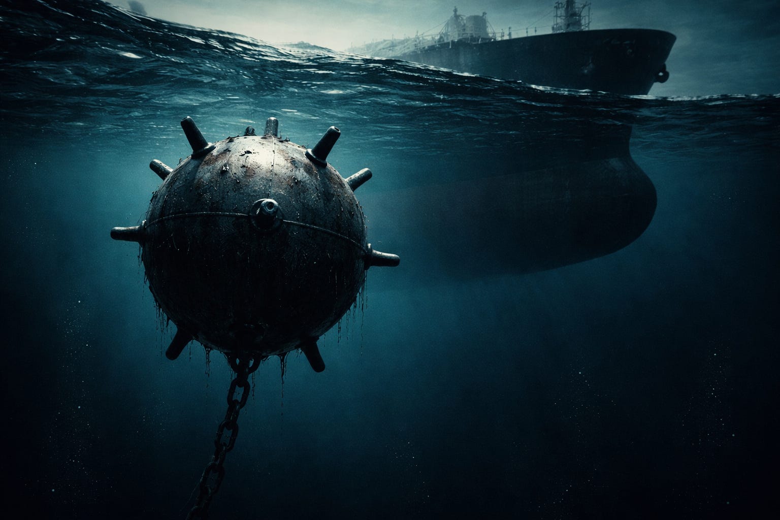
The lesson Iran drew was not that mines were ineffective. The lesson was that mines were cheap, deniable, and psychologically devastating in a way that conventional naval power is not. A mine doesn’t need to detonate to close a strait. It needs only to make every underwriter at Lloyd’s of London refuse to issue war-risk insurance for the voyage.
Which is exactly what has happened in 2026. Following US-Israeli strikes on Iranian infrastructure, the Islamic Revolutionary Guard Corps announced the deployment of hundreds of sea mines across the strait’s shipping lanes. The US Navy has reportedly sunk sixteen Iranian mine-laying vessels. Tanker traffic has slowed to near-standstill. Brent crude has reached $119 per barrel. Qatar has declared force majeure on LNG shipments. The mines don’t need to explode. They need only to exist, possibly, perhaps, somewhere out there in 39 kilometres of dark water.
The geography didn’t change. The insurance did. That was enough.
🔮 The Real Consequence of This Crisis Isn’t the Oil Price
In 1625, the Portuguese fleet and a combined English-Dutch force exchanged 17,000 cannon shots off this island over two days. Every ship remained afloat at the end. Portuguese observers described the sound as “the mouths of Hell opening.” A month later, the trade resumed. The merchants came back. The tolls were collected. Because the geography permitted no alternative.
The second-order consequence of the 2026 Iran-Hormuz crisis is not the oil price, which will correct itself. It is the acceleration of Chinese strategic interest in these waters. China has historically allowed the United States to police the strait on its behalf, a delegation of security that is now visibly reaching its end. Beijing cannot indefinitely allow its 90-million-barrel-a-month lifeline to depend on Washington’s goodwill. The question of who patrols the Strait of Hormuz in twenty years is the most consequential unanswered question in global energy geopolitics right now, and this crisis has moved it from a seminar room to a trading floor.
And Oman, quiet and steady, cartographically improbable Oman, perched on Musandam with its exclaves and its ancient mediation instincts, will remain the indispensable back channel. It always has been. It is the one power that all parties will still talk to when all other lines go dark.
The whale skull is still in the square. The mines are somewhere beneath the water. And twenty percent of the world’s oil supply has nowhere else to go.
The Parsi uncle, it turns out, has always run the room.
Happy Sunday, wherever and whenever this finds you.
If this resonated, share it with someone who needs to understand why 39 kilometres of water is the most important geography lesson of 2026. A Man Who Blogs drops twice every week. The A2Z Fintech podcast, now in its second season, is available on YouTube, Spotify, Apple Podcasts, and 12 additional platforms.